

Garmo Negro (3064 m) on the left and Pico de Pondiellos (2917 m) on the right.
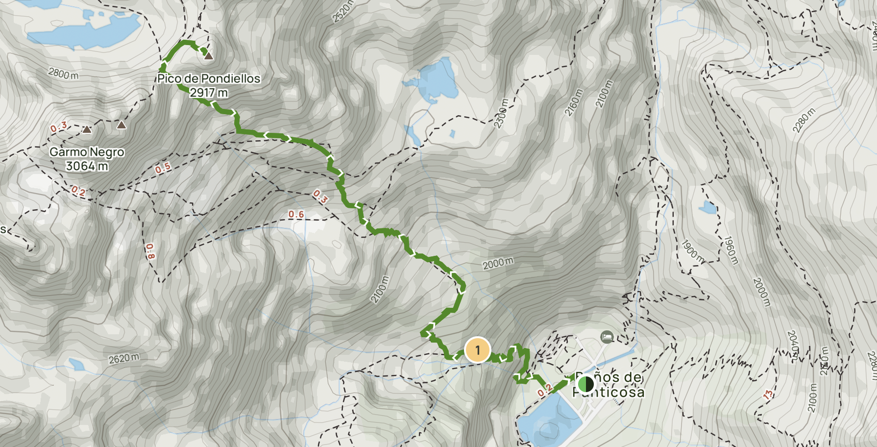
The route for Pico de Pondiellos.
Overview
Pico de Pondiellos, rising to 2,917 metres, offers a challenging and rewarding hike above the scenic valley of Baños de Panticosa. With an elevation gain of approximately 1,217 metres from the valley floor, this out-and-back route takes around 5 to 6 hours, depending on your pace and weather conditions.
Getting There & Accommodation
Baños de Panticosa is nestled in a natural bowl in the Spanish Pyrenees, easily accessible by car. Within the valley are several spa hotels offering overnight accommodation – perfect for a relaxing stay before or after your hike. There’s also a semi-public spa in the area, featuring outdoor thermal pools ideal for unwinding sore muscles after a long day’s trekking.

Sunset in the basin of the valley looking down towards the direction of Panticosa.
Start Point: Baños de Panticosa (1,700m approx.)
The hike begins at the car park or spa complex area of Baños de Panticosa. You'll likely start from near the Refugio Casa de Piedra, a common base for hikers in the area.
Look for the blue trail markings at the forest edge, behind the spa buildings. The path is well-trodden early on, climbing steadily into the trees. The first section is steep, consisting of well-built switchbacks, and shaded under thick pine forest. Within 15–20 minutes, you'll pass your first waterfall – a great spot to catch your breath and take photos. Continue following the switchbacks; the trail weaves through mossy glades and occasional rock outcrops.

A view of the route winding up the walls of the valley towards the towering peaks above.
Mid Section: Tree Line to Fork in the Trail (~2,300m)
After around 90 minutes of steady climbing the forest begins to thin out noticeably as you approach 2,300m. The views open up behind you – take a look back for your first sweeping vista of Baños de Panticosa below.

Views from the trail fork heading towards Garmo Negro.
You’ll soon reach a trail fork marked by a large rock cairn:
To the right is the route to Garmo Negro (3,064m).
For Pico de Pondiellos, keep heading straight, ascending towards the rocky basin.
From here, the trail gets rougher underfoot. There are no more trees, and the next sections involve more careful foot placement.

The trees start to thin out midway up the face of the valley.
Rocky Basin to Ridge (~2,500–2,800m)
You are now entering the boulder field zone. Trail markings become scarcer – look for stone cairns (hit or miss) and occasional faint tracks. The gradient increases steadily. Hiking poles help greatly here, particularly with balance and leg fatigue. In this zone, you'll begin light bouldering – not true climbing, but you’ll need to use your hands in places.

The rocky boulder zone of the mountain.
As you climb, you’ll skirt the edge of a small cirque, and the views of the Panticosa valley and surrounding peaks become more expansive. Navigation is challenging in this part. There may be multiple faint paths over the boulders – try to maintain a northwest line, aiming towards the high ridgeline between Garmo Negro (right) and Pico de Pondiellos (left).

The other worldly looking landscape of the peaks and valleys.
Final Ascent: Scree Slope to Summit Ridge (~2,800m–2,917m)
Once you’ve reached the base of the summit ridge, you’ll face the final and most strenuous push. The route to Pico de Pondiellos breaks left from the Garmo Negro path and leads up a steep scree slope. Expect tight, unstable switchbacks, where footing can be loose. Progress is slow, and the trail is poorly defined. Some hikers prefer zig-zagging off-trail across more stable rock instead of following the faint scree track.

The spa far below on the valley floor with the final boulder section in the foreground.
As you approach the summit ridge, the landscape becomes wild and rugged, resembling a Martian scene with red-orange rock hues.
Summit: Pico de Pondiellos (2,917m)

The Summit of Pico de Pondiellos in the foreground.
At the top, you’ll reach a small rocky summit, with limited space to sit or stand comfortably. There’s usually a small summit cairn marking the top. From here, you’ll have a 360° panorama of the surrounding Pyrenees. You can see the Ibón de Pondiellos Superior far below – an alpine lake nestled in the bowl between the surrounding peaks.

On the peak of Pico de Pondiellos.

The summit stone of Pico de Pondiellos.

Ibón de Pondiellos Superior in the summit bowl.
Looking across the ridge, you may spot other hikers heading towards Infierno Central (3,080m) or traversing between Garmo Negro and Pico de los Infiernos. Take a break here if conditions are safe – it’s a stunning place for photos and rest, though often exposed to wind.
Descent
Retrace your steps carefully. The descent is harder on the knees, particularly over the boulders and scree.
It is not marked obviously, so remain oriented towards the Baños de Panticosa valley floor, which remains visible in most sections. Use poles to reduce strain and take your time descending through the unstable terrain.

Heading back down to the hotel, a long way down!
Watch your footing especially in the boulder fields – descending too quickly can lead to minor slips or wrong turns. If in doubt, head towards Refugio Casa de Piedra, which is visible once lower down.
Optional Finish: Spa or Cold Dip
Once back in the valley you can treat yourself to a refreshing swim in the cold lake (though very bracing!) or enjoy a relaxing soak in one of the public or hotel-run spas, many of which feature warm thermal pools.

Enjoying the sunset from the edge of the lake after a long hike up and down!
Tips & Essentials
Good fitness is required – this is a physically demanding hike.
Hiking poles are highly recommended for stability on loose scree and boulders.
Carry plenty of water and high-energy snacks.
Sturdy boots with good grip are essential.
GPS or an offline map can be helpful due to the lack of clear signage.

The peaks of Garmo Negro and Pico de Pondiellos looming above the lake.
Final Thoughts
Pico de Pondiellos is a fantastic choice for hikers seeking solitude, views, and a proper mountain challenge. Though steep and rocky, the scenery more than compensates for the effort. And with the bonus of natural spas and alpine lakes below, it makes for a memorable adventure in the heart of the Spanish Pyrenees.