

The Sulzkogel summit (3016m) standing tall with the path winding up through the snow fields.
Overview
Sulzkogel is a striking alpine peak located in the Kühtai region of Tirol, Austria. The village of Kühtai itself sits at around 2,000 metres above sea level, making this a high-altitude hike with stunning views and relatively accessible elevation gain. The summit of Sulzkogel reaches 3,016 metres, offering panoramic vistas across the surrounding peaks.
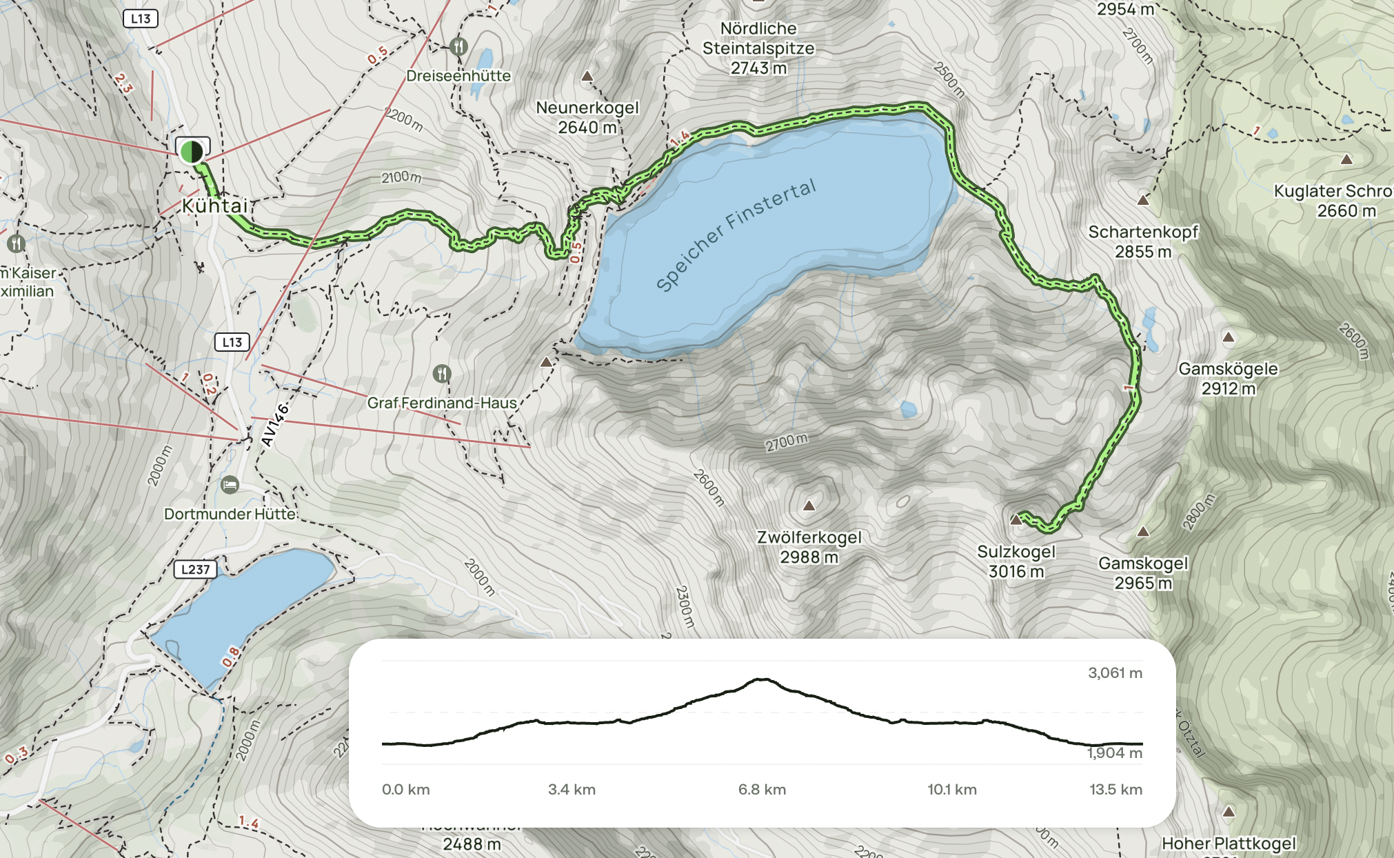
There are multiple start points in the town before getting to the damn. and easier routes back around the damn and ski lifts as well.

Admiring the view of the surrounding mountains from the peak!
This route is highly recommended for experienced hikers looking for a rewarding full-day excursion. While the route is well-marked and straightforward in summer, spring conditions can present additional challenges due to snowmelt and unstable terrain. Proper equipment and a good level of fitness are essential.
Getting Started: Route Options
You have two main options for beginning the hike:
Option 1: Via Bergbahnen Kühtai Ski Lift
This is the gentler approach. From the ski lift station, a wide fire road with a gradual incline winds around the side of the Pockkogel towards the reservoir dam. It's a comfortable and steady route suitable for those preferring a more leisurely start.

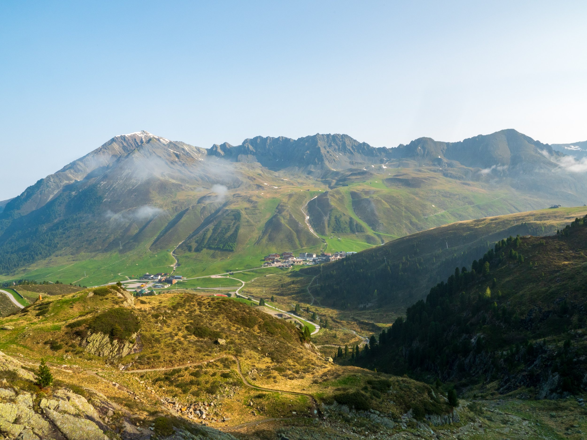
The town of Kuhtai with trail up the ski slopes for a more leisurely option 1.
Option 2: Valley Approach Behind the Ski Hotels (Recommended for Adventure Seekers)
This is the route I personally took. Starting behind the ski hotels, this path leads through a valley towards the foot of the dam. It’s a steeper and shorter ascent, featuring narrower trails, switchbacks, and a more varied terrain. Though physically more demanding, it’s an excellent way to immerse yourself in the alpine landscape right from the beginning.
A view of the option 2 route leading up the valley to the base of the damn.
To the Dam and Beyond
Upon reaching the dam, the hike truly begins to open up. The path traces the edge of the reservoir, a serene stretch made more challenging in spring by lingering snowfields. When I hiked in late spring, snow persisted from approximately 2,300 metres upwards.
Several snow patches had to be carefully crossed around the lake’s edge. As long as you move steadily and cautiously, they are manageable. Hiking poles and microspikes are strongly recommended during this time of year.

A view of the path leading around the left side of the lake before getting to the start of the summit valley.
Climbing Towards the Summit
After circling the lake, the trail steepens and the proper ascent begins. Despite the incline, the path is very well marked—typically every 10 metres or so—which makes route-finding easy even in partial snow cover.
As I progressed towards the summit, large snowfields remained in shaded areas, especially between 2,500 and 2,800 metres. Early in the morning, the snow was firm and relatively stable, but became increasingly slushy and unstable as the day warmed. Again, take your time and plan your steps carefully.

The opposite side of the lake and start of the ascent to the summit.
The trail gradually leads left around a prominent cliff, involving a few stream crossings. Once past the cliff, you enter a hidden upper valley between Schartenkogel and Sulzkogel. This section isn’t visible from the village below but is straightforward to follow.

The route leads around this large cliff. in snowy conditions watch out for deep pockets of nowhere
Thanks to earlier hikers, there was a broken trail through the snow, which I followed from one rocky outcrop to the next. Around 2,700 meters, you’ll pass two small natural alpine lakes—a scenic and peaceful point for a quick break.

the two small lakes at the end of the small valley leading to the summit.

The snowfields in the valley leading up to the ridge and summit of Sulzkogel.
Final Push to the Summit
Beyond 2,800 metres, the snow began to thin out, likely due to increased sun exposure. The final stretch to the summit consisted of steep but short switchbacks. These were well defined and clearly marked.

The path leading towards the ridge line and summit of Sulzkogel just to the right of frame.
Upon reaching the ridge, you're rewarded with breathtaking views across the surrounding ranges. To one side, you can even spot a second hydroelectric dam under construction in the neighbouring valley.
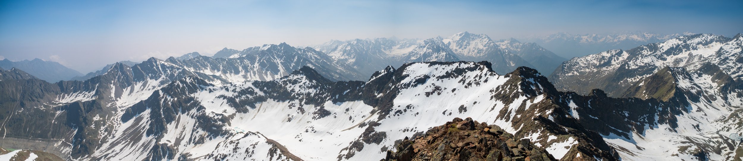
The summit itself is a narrow to medium ridge, but there is ample space to safely move around and scramble across the summit rocks. The 360-degree panorama makes every step worthwhile.
The view looking back towards the route up from the summit.

The Sulzkogel summit (3016m)

One of two crosses on the summit.

On a clear day you get views like this! I think maybe that is Solden that in far off vista.
Descent and Return
Due to the slushy snow, I took my time descending—especially over snowfields that had become unstable throughout the afternoon. Once I reached solid ground, I opted for the gentler fire road route leading back to the ski lift station. It made for a longer return, but the lower gradient was much easier on tired legs.

Looking back at the summit of Sulzkogel. The large cliff and waterfall in the foreground
Summary & Recommendations
Sulzkogel is a spectacular and rewarding hike, offering stunning scenery and a solid physical challenge. Here are a few key tips:
Best Season: Late summer to early autumn for snow-free trails. Spring adds adventure but also difficulty.
Gear: Good hiking boots, poles, microspikes (especially in spring), and plenty of layers (depending when you are hiking, in spring I found two with a small packable windbreak was plenty to keep warm when the wind kicked in.)
Fitness: A decent level of fitness is required due to the steep ascent / decent and high altitude.
Navigation: The trail is well-marked, but snow cover can obscure the path—so be prepared to follow previous tracks or use GPS.

Approximate altitude gain.

A view of the lake and damn from the summit.
Compared to other alpine hikes such as Pico Pondellios in Spain (known more for boulder and slate scrambling), Sulzkogel offers a mix of snowfields, alpine lakes, and high ridge walking. It’s a varied and beautiful route that stands out in the Tirol region.
Whether you're an avid hiker or simply looking for a mountain adventure in Austria, Sulzkogel is well worth the effort. If you want to see more of the pictures from the hike more are available in the gallery in the Explore tab! I’ll also add on a link to the video version of this hike once I finish editing!