

The summit of Pirchkogel (2828 m)

Pirchkogel hiking route.
Overview
Pirchkogel is a prominent peak on the opposite side of the valley from Sulzkogel, rising to 2,828 metres. While it shares the dramatic alpine setting, Pirchkogel is generally more accessible, offering multiple route options from the valley floor. The hike covers approximately 7.6 km with 781 metres of elevation gain, typically taking around 4.5 hours to complete.

Alpine views from the hike up to Pirchkogel.
This guide describes a moderately challenging circular route beginning in Kühtai, ideal for those with a reasonable level of fitness and a good head for heights.
Start Point: Kühtai
The hike begins in Kühtai, one of Austria’s highest year-round alpine villages. From here, several trail options present themselves. Given that this was the day after a more demanding ascent of Sulzkogel, I chose a gentler start via the ski runs. An alternative, steeper option climbs directly up a black ski run (visible on local maps), but I opted for a more gradual incline up to the Kaiserbahn ski lift station.
Initial Ascent & Scenic Views
From the outset, the route opens up stunning vistas of the mountain range across the valley and towards Innsbruck. On the day I hiked, the weather was glorious—clear blue skies and warm summer sun.

Looking down the valley from Kühtai.
The initial climb follows broad, sweeping switchbacks, likely the blue ski runs of Kühtai, eventually leading to the Zum Kaiser Maximilian Hut. Although closed during my visit, it would undoubtedly make an excellent rest stop during peak hiking season.

The view from the Hut.
Midway: Alpine Pastures & Lakes
Beyond the hut, the trail climbs through peaceful sheep pastures—the animals are used to hikers and generally calm. Higher up, you’ll find a series of alpine lakes, both natural and man-made, adding to the scenic variety.

Gossenkölle Lake.
Just past the ski lift station, the trail transitions into a narrower single-track path, with more rocky terrain. On your right, you’ll pass the shimmering Gossenkölle, especially striking in the morning light.
Final Ascent: Steeper & More Technical
Here the hike becomes notably more demanding. Some patches of snow may linger on the less sunny side of the slope, and the incline steepens considerably. A few faint trails offer different lines—some higher, some lower—but care is needed to avoid slipping.

Looking down from the route towards the top of the ski lift.
I highly recommend bringing hiking poles for added stability. There are also fixed ropes along steeper parts closer to the summit ridge, which are helpful in poor conditions.

A view from the ridge with Hinterer Grieskogel (2,684m) in the foreground.
Once you crest the ridge, you’re rewarded with views of Hinterer Grieskogel (2,684m) and the Griebßkogelscharte. The ridge section is moderately exposed but not dangerously so. A head for heights is beneficial here, though the trail is well-marked and generally easy to follow.

Some of the last remaining snow patches on Pirchkogel.
Summit: Pirchkogel (2,828m)
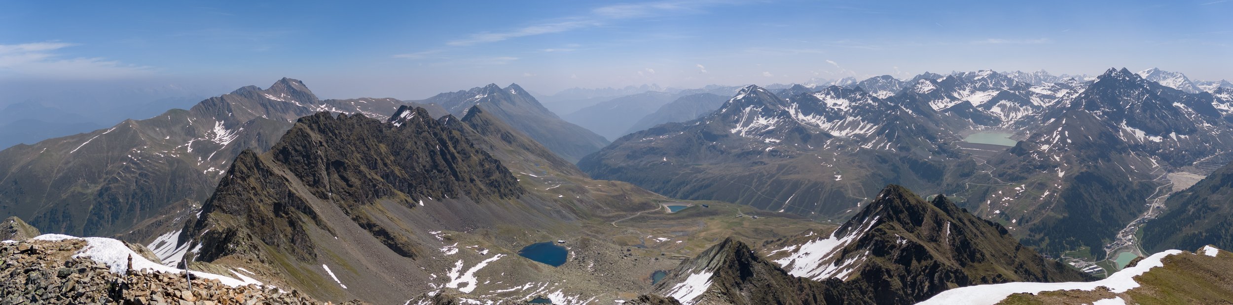
The final push involves a mix of switchbacks and minor bouldering before reaching the summit. As the tallest peak on this side of the valley, the views from the top are truly spectacular, offering a commanding perspective over the surrounding peaks and valleys of Tyrol and Kühtai.

A view from the summit, well worth the effort!

The summit stone.
At the summit, you’ll find stone cairns, summit crosses, and markers. There’s also a short 5-minute extension to a secondary cross at a slightly lower point, though I chose to rest and enjoy the views from the main summit.

The peaks of Kühtai.
Essential Kit & Tips
Footwear: Sturdy hiking boots with good grip.
Poles: Highly recommended for balance and support.
Fitness: A moderate to high level of fitness is required due to the steep final quarter.
Head for Heights: Helpful for the ridge section, though not technically exposed.
Weather: Always check conditions—snow patches may remain well into summer.
Final Thoughts
A drone view of the valley and route to the summit.

Looking towards the lower valleys near Kühtai.
Pirchkogel is a fantastic alpine hike offering a mix of gentle starts, alpine pastures, technical ridge walking, and panoramic summit views. It's less committing than Sulzkogel but still rewarding and exciting. Whether you’re tackling it as a follow-up to a longer trek or as a standalone day hike, it’s a beautiful route showcasing the best of the Austrian Alps. If you want to see more of the pictures from the hike be sure to check out the full gallery for Kühtai in the explore tab!