

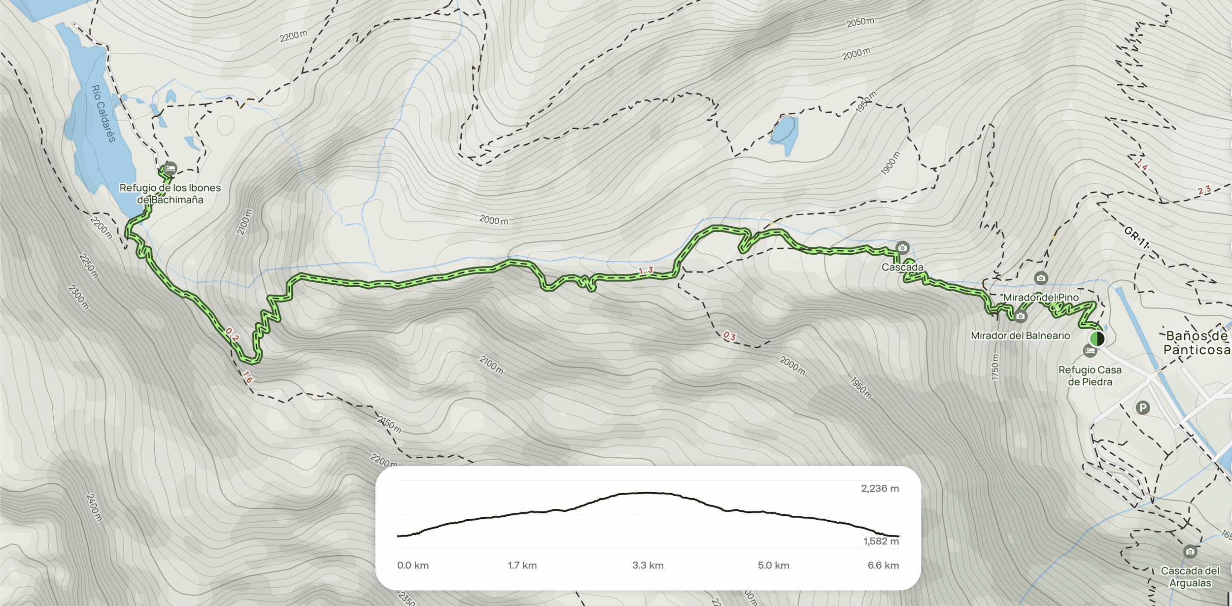
The route up to the lake.
Distance: 6.6 km (return)
Elevation Gain: 554 m
Difficulty: Moderate to Challenging
Location: Spanish Pyrenees
Estimated Time: 3–5 hours (return)
Best Time to Visit: May–October (avoid peak summer for fewer crowds)
Overview
This enjoyable mountain route follows a gorge path up to the stunning Cascada de Piedra waterfall and ends at the Aguja de Bachimaña hut, which sits beside an artificial alpine lake at around 2,200 metres elevation. Following the iconic GR®11 Senda Pirenaica, this trail is perfect for intermediate to experienced hikers seeking a blend of dramatic scenery, solitude, and a touch of adventure.

Looking up the valley towards the waterfalls.
Trail Description
The route begins with immediate switchbacks, climbing steadily towards the Mirador del Pino, your first waterfall viewpoint. A little further along, you'll find a scenic platform offering panoramic views over the basin-like valley that houses several mountain resorts.

A view of the basin from the lookout platform at the start of the hike.
After a brief, straightforward section of relatively flat terrain, the trail reaches a slippery rock area—here, fixed chains are in place to assist with footing, especially helpful when the river is swollen. During our hike in September, a recent storm meant the rivers and waterfalls were in spectacular full flow, adding drama to the already scenic landscape.

One for the first impressive waterfalls you’ll come across at the starting point of the hike.
Beyond this point, the trail involves light rock-hopping rewarded with an impressive view of the next major waterfall. This is followed by a gentler section with a mild incline. Although there are a few exposed edges with steep drop-offs, the path remains generally manageable.
In autumn, the trail is especially beautiful, with vibrant foliage transforming the landscape into a stunning display of reds, oranges, and golds.

Some of the fall colors in the trees.
Roughly 2 km in, the trail ascends once more, hugging the valley walls and including some bouldering sections assisted by fixed chains. This climb leads to a higher plateau, where you’ll encounter several overflowing streams and lake run-offs that cascade into the valley, feeding the impressive Cascada del Fraile.
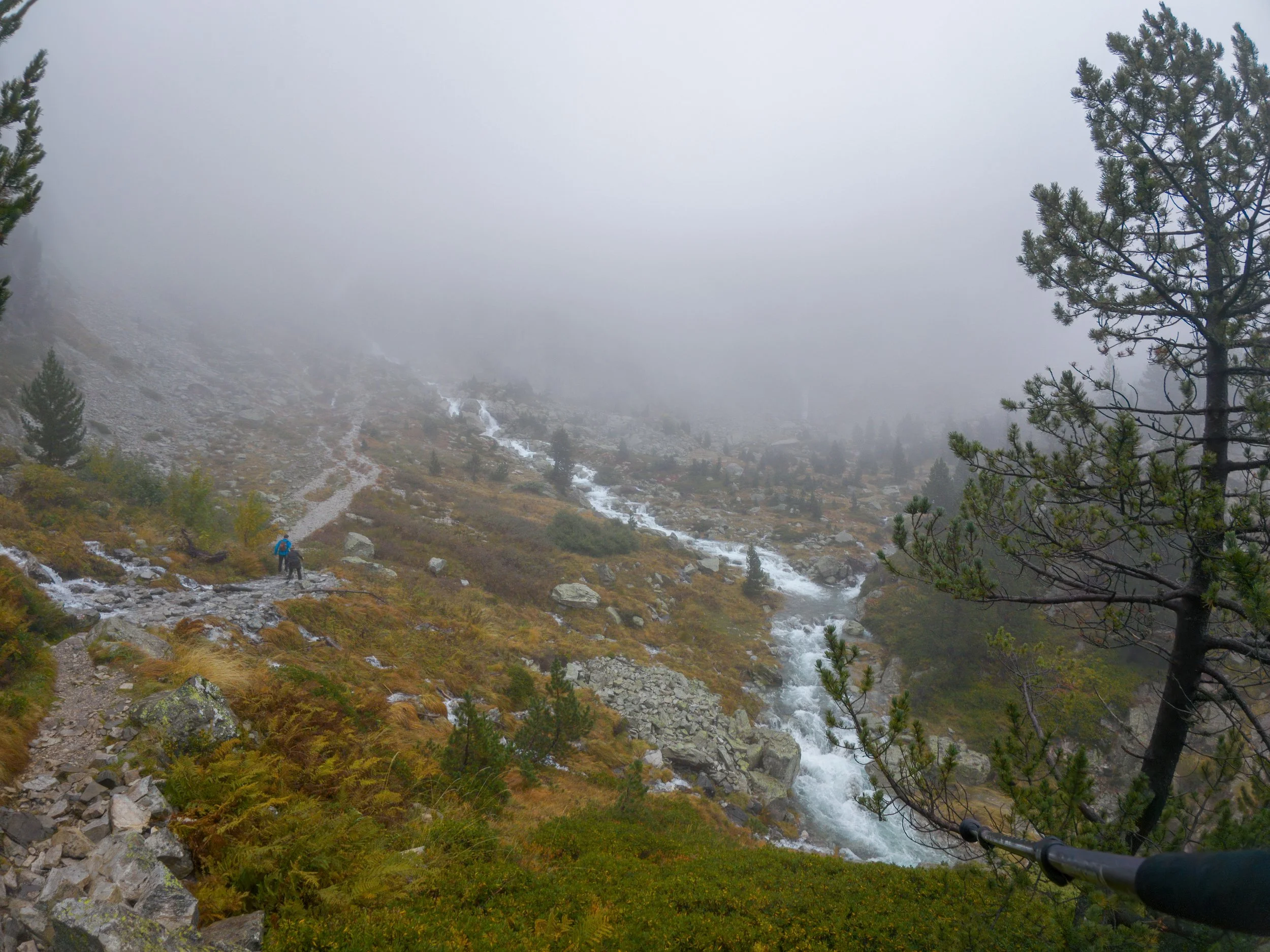
The basin before Cascada del Fraile.
As the mist lifted and rain subsided during our visit, the basin took on a truly otherworldly atmosphere, with low clouds drifting across the ridgelines and waterfalls thundering in the background.

The top of the waterfall leading into the large basin.
The final and most strenuous part of the hike is a steep switchback ascent, which serves as a real test of your cardio fitness. It leads to the dam and lake above, from where you can either head straight to the Refuge hut or, if you’ve energy left, continue on a much longer circuit around the Río Caldarés.
Tips & Recommendations
Footwear: Sturdy hiking boots with excellent grip are essential due to slippery rock, mist, and waterfall spray.
Gear: Trekking poles and a waterproof jacket are highly recommended.
Weather: Conditions can change rapidly—check the forecast and be prepared for rain or mis..
Timing: For a quieter experience, avoid July and August. September can offer ideal hiking conditions for cooler temperatures and less people.
Water & Snacks: No facilities along the route—bring sufficient water and energy-rich snacks.
Navigation: The trail is well-marked, but carrying a map or GPS device is still advised.
Summary

The views are well worth the hike up to the top.
This is a rewarding alpine hike packed with natural beauty—towering waterfalls, dramatic switchbacks, mist-shrouded valleys, and golden autumn colours. Though challenging in places, it’s accessible to most fit hikers and offers a real sense of wilderness without straying too far from civilisation.